
Horten topographic map
Click on the map to display elevation.
About this map
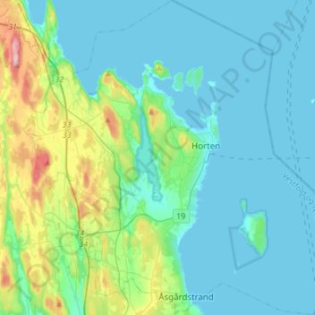
Name: Horten topographic map, elevation, terrain.
Location: Horten, Vestfold, Norway (59.34094 10.33350 59.47988 10.59527)
Average elevation: 34 m
Minimum elevation: -1 m
Maximum elevation: 196 m
Other topographic maps
Click on a map to view its topography, its elevation and its terrain.
Kodal
An ancient hill fort can be seen about 5 kilometres (3.1 mi) from the village centre of Kodal, connected by a hiking trail from the village centre. A closer parking lot can be found at Kodalveien 414. The trail is marked by blue paint on trees and rocks, and a variety of interpretive signs describing the fauna…
Average elevation: 75 m