Geolocate

Eidsfoss topographic map

Click on the map to display elevation.

About this map

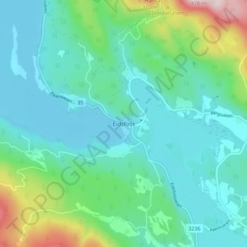
Name: Eidsfoss topographic map, elevation, terrain.

Location: Eidsfoss, Holmestrand, Vestfold, 3095, Norway (59.57571 10.01740 59.61571 10.05740)

Average elevation: 107 m

Minimum elevation: 19 m

Maximum elevation: 441 m

Other topographic maps

Click on a map to view its topography, its elevation and its terrain.

Horten

Norway > Vestfold

Average elevation: 34 m

Holmestrand

Norway > Vestfold

Average elevation: 187 m

Veierland

Norway > Vestfold > Kjøpmannskjær

Average elevation: 8 m

Sandefjord

Norway > Vestfold

Average elevation: 45 m

Hvasser

Norway > Vestfold > Hvasser

Average elevation: 6 m

Tønsberg

Norway > Vestfold

Average elevation: 83 m

Larvik

Norway > Vestfold

Average elevation: 86 m

Gear up for your next adventure:

🥾Waterproof Trail Shoes - Shoes designed to handle wet terrain
🦟Insect Repellent - Keep mosquitoes and black flies away in wooded areas
🌬️Windproof Camp Stove - Efficient cooking even on exposed mountain peaks
🎒Backpack Rain Cover - External shield to keep your entire pack dry
🧥Waterproof Pants - Keep dry during rainy hiking conditions

As an Amazon Associate, this site earns from qualifying purchases at no extra cost to you.