
Gryon topographic map
Click on the map to display elevation.
Gryon
The municipality is located in the Aigle district, on a narrow terrace at an elevation of 1,110 m (3,640 ft) between the Gryonne and Avançon canyons. The commune is composed of multiple settlements, which include the Gryon village, Barboleuse, Alpe des Chaux, Taveyanne, and Peuffeyre. In the western part behind the forests lies the alpine pasture of Taveyanne. The highest point of the commune reaches 2'620 m a.s.l. on the slopes of mountain Culan, which is part of the Diablerets massif. The lowest point is located at an altitude of 680 m at Peuffeyre next to the river Avançon d'Anzeinde.
About this map
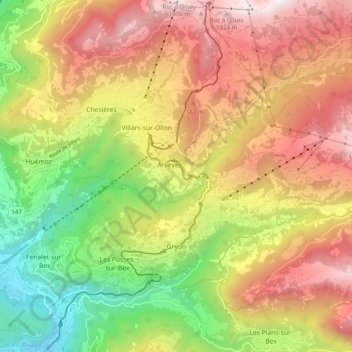
Name: Gryon topographic map, elevation, terrain.
Location: Gryon, District d'Aigle, Vaud, 1882, Switzerland (46.26606 7.05242 46.31035 7.15140)
Average elevation: 1,240 m
Minimum elevation: 457 m
Maximum elevation: 2,014 m
Other topographic maps
Click on a map to view its topography, its elevation and its terrain.