
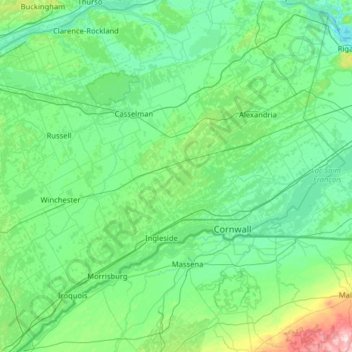
Stormont, Dundas and Glengarry Counties topographic map
Interactive map
Click on the map to display elevation.
About this map
Name: Stormont, Dundas and Glengarry Counties topographic map, elevation, terrain.
Average elevation: 86 m
Minimum elevation: 20 m
Maximum elevation: 595 m
Other topographic maps
Click on a map to view its topography, its elevation and its terrain.
Apple Hill
Canada > Ontario > Stormont, Dundas and Glengarry Counties > North Glengarry
Apple Hill, North Glengarry, Stormont, Dundas and Glengarry Counties, Eastern Ontario, Ontario, K0C 1B0, Canada
Average elevation: 90 m
Ingleside
Canada > Ontario > Stormont, Dundas and Glengarry Counties > South Stormont
Ingleside, South Stormont, Stormont, Dundas and Glengarry Counties, Eastern Ontario, Ontario, K0C 1M0, Canada
Average elevation: 78 m
Bainsville
Canada > Ontario > Stormont, Dundas and Glengarry Counties > South Glengarry
Bainsville, South Glengarry, Stormont, Dundas and Glengarry Counties, Eastern Ontario, Ontario, K0C 1E0, Canada
Average elevation: 50 m
Stormont, Dundas and Glengarry
Canada > Ontario > Stormont, Dundas and Glengarry Counties
Stormont, Dundas and Glengarry, Stormont, Dundas and Glengarry Counties, Eastern Ontario, Ontario, Canada
Average elevation: 153 m
North Dundas
Canada > Ontario > Stormont, Dundas and Glengarry Counties
North Dundas, Stormont, Dundas and Glengarry Counties, Eastern Ontario, Ontario, Canada
Average elevation: 81 m
North Stormont
Canada > Ontario > Stormont, Dundas and Glengarry Counties
North Stormont, Stormont, Dundas and Glengarry Counties, Eastern Ontario, Ontario, Canada
Average elevation: 82 m
Summerstown
Canada > Ontario > Stormont, Dundas and Glengarry Counties > South Glengarry
Summerstown, South Glengarry, Stormont, Dundas and Glengarry Counties, Eastern Ontario, Ontario, Canada
Average elevation: 49 m
Osnabruck
Canada > Ontario > Stormont, Dundas and Glengarry Counties > South Stormont
Osnabruck, South Stormont, Stormont, Dundas and Glengarry Counties, Eastern Ontario, Ontario, Canada
Average elevation: 85 m
Moose Creek
Canada > Ontario > Stormont, Dundas and Glengarry Counties > North Stormont
Moose Creek, North Stormont, Stormont, Dundas and Glengarry Counties, Eastern Ontario, Ontario, K0C 1W0, Canada
Average elevation: 87 m
Martintown
Canada > Ontario > Stormont, Dundas and Glengarry Counties > South Glengarry
Martintown, South Glengarry, Stormont, Dundas and Glengarry Counties, Eastern Ontario, Ontario, K0C 1S0, Canada
Average elevation: 66 m
Brown House Corner
Canada > Ontario > Stormont, Dundas and Glengarry Counties > South Glengarry
Brown House Corner, South Glengarry, Stormont, Dundas and Glengarry Counties, Eastern Ontario, Ontario, K0C 1L0, Canada
Average elevation: 67 m
Green Valley
Canada > Ontario > Stormont, Dundas and Glengarry Counties > South Glengarry
Green Valley, South Glengarry, Stormont, Dundas and Glengarry Counties, Eastern Ontario, Ontario, K0C 1L0, Canada
Average elevation: 79 m
Ormond
Canada > Ontario > Stormont, Dundas and Glengarry Counties > North Dundas
Ormond, North Dundas, Stormont, Dundas and Glengarry Counties, Eastern Ontario, Ontario, Canada
Average elevation: 77 m
Glen Stewart
Canada > Ontario > Stormont, Dundas and Glengarry Counties > South Dundas
Glen Stewart, South Dundas, Stormont, Dundas and Glengarry Counties, Eastern Ontario, Ontario, Canada
Average elevation: 76 m
Dalkeith
Canada > Ontario > Stormont, Dundas and Glengarry Counties > North Glengarry
Dalkeith, North Glengarry, Stormont, Dundas and Glengarry Counties, Eastern Ontario, Ontario, Canada
Average elevation: 70 m
Lake Saint-Francis
Canada > Ontario > Stormont, Dundas and Glengarry Counties > South Glengarry
Lake Saint-Francis, South Glengarry, Stormont, Dundas and Glengarry Counties, Eastern Ontario, Ontario, J0P 1B0, Canada
Average elevation: 116 m
Timmins Drain
Canada > Ontario > Stormont, Dundas and Glengarry Counties > North Dundas
Timmins Drain, North Dundas, Stormont, Dundas and Glengarry Counties, Eastern Ontario, Ontario, Canada
Average elevation: 72 m
Winchester
Canada > Ontario > Stormont, Dundas and Glengarry Counties > North Dundas
Winchester, North Dundas, Stormont, Dundas and Glengarry Counties, Eastern Ontario, Ontario, K0C 2K0, Canada
Average elevation: 76 m
South Glengarry
Canada > Ontario > Stormont, Dundas and Glengarry Counties
South Glengarry, Stormont, Dundas and Glengarry Counties, Eastern Ontario, Ontario, Canada
Average elevation: 65 m
Finch
Canada > Ontario > Stormont, Dundas and Glengarry Counties > North Stormont
Finch, North Stormont, Stormont, Dundas and Glengarry Counties, Eastern Ontario, Ontario, Canada
Average elevation: 80 m
Dunvegan
Canada > Ontario > Stormont, Dundas and Glengarry Counties > North Glengarry
Dunvegan, North Glengarry, Stormont, Dundas and Glengarry Counties, Eastern Ontario, Ontario, Canada
Average elevation: 87 m
Hallville
Canada > Ontario > Stormont, Dundas and Glengarry Counties > North Dundas
Hallville, North Dundas, Stormont, Dundas and Glengarry Counties, Eastern Ontario, Ontario, Canada
Average elevation: 91 m
Long Sault
Canada > Ontario > Stormont, Dundas and Glengarry Counties > South Stormont > Long Sault
Long Sault, South Stormont, Stormont, Dundas and Glengarry Counties, Eastern Ontario, Ontario, K0C 1P0, Canada
Average elevation: 77 m
Finch
Canada > Ontario > Stormont, Dundas and Glengarry Counties > North Stormont
Finch, North Stormont, Stormont, Dundas and Glengarry Counties, Eastern Ontario, Ontario, K0C 1K0, Canada
Average elevation: 83 m
Maxville
Canada > Ontario > Stormont, Dundas and Glengarry Counties > North Glengarry
Maxville, North Glengarry, Stormont, Dundas and Glengarry Counties, Eastern Ontario, Ontario, K0C 1T0, Canada
Average elevation: 100 m
Alexandria
Canada > Ontario > Stormont, Dundas and Glengarry Counties > North Glengarry
Alexandria, North Glengarry, Stormont, Dundas and Glengarry Counties, Eastern Ontario, Ontario, K0C 1A0, Canada
Average elevation: 84 m
Chesterville
Canada > Ontario > Stormont, Dundas and Glengarry Counties > North Dundas
Chesterville, North Dundas, Stormont, Dundas and Glengarry Counties, Eastern Ontario, Ontario, K0C 1H0, Canada
Average elevation: 74 m
Morrisburg
Canada > Ontario > Stormont, Dundas and Glengarry Counties > South Dundas
Morrisburg, South Dundas, Stormont, Dundas and Glengarry Counties, Eastern Ontario, Ontario, K0C 1X0, Canada
Average elevation: 79 m
South Lancaster
Canada > Ontario > Stormont, Dundas and Glengarry Counties > South Glengarry
South Lancaster, South Glengarry, Stormont, Dundas and Glengarry Counties, Eastern Ontario, Ontario, K0C 1N0, Canada
Average elevation: 47 m
Lancaster
Canada > Ontario > Stormont, Dundas and Glengarry Counties > South Glengarry
Lancaster, South Glengarry, Stormont, Dundas and Glengarry Counties, Eastern Ontario, Ontario, K0C 1N0, Canada
Average elevation: 50 m
Williamstown
Canada > Ontario > Stormont, Dundas and Glengarry Counties > South Glengarry > Williamstown
Williamstown, South Glengarry, Stormont, Dundas and Glengarry Counties, Eastern Ontario, Ontario, K0C 2J0, Canada
Average elevation: 55 m
Monkland
Canada > Ontario > Stormont, Dundas and Glengarry Counties > North Stormont
Monkland, North Stormont, Stormont, Dundas and Glengarry Counties, Eastern Ontario, Ontario, K0C 1V0, Canada
Average elevation: 102 m
Dalhousie Mills
Canada > Ontario > Stormont, Dundas and Glengarry Counties > South Glengarry
Dalhousie Mills, South Glengarry, Stormont, Dundas and Glengarry Counties, Eastern Ontario, Ontario, Canada
Average elevation: 75 m