Geolocate

Ingleside topographic map

Interactive map

Click on the map to display elevation.

About this map

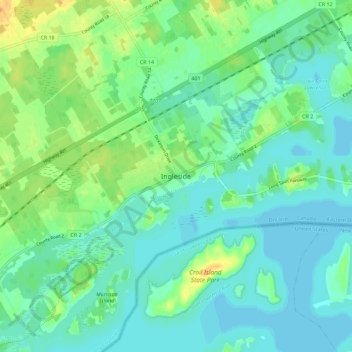
Name: Ingleside topographic map, elevation, terrain.

Location: Ingleside, South Stormont, Stormont, Dundas and Glengarry Counties, Eastern Ontario, Ontario, K0C 1M0, Canada (44.95549 -75.02674 45.03549 -74.94674)

Average elevation: 78 m

Minimum elevation: 69 m

Maximum elevation: 96 m

Other topographic maps

Click on a map to view its topography, its elevation and its terrain.

Osnabruck

Canada > Ontario > Stormont, Dundas and Glengarry Counties > South Stormont

Osnabruck, South Stormont, Stormont, Dundas and Glengarry Counties, Eastern Ontario, Ontario, Canada

Average elevation: 85 m

Long Sault

Canada > Ontario > Stormont, Dundas and Glengarry Counties > South Stormont > Long Sault

Long Sault, South Stormont, Stormont, Dundas and Glengarry Counties, Eastern Ontario, Ontario, K0C 1P0, Canada

Average elevation: 77 m