
North Stormont topographic map
Click on the map to display elevation.
About this map
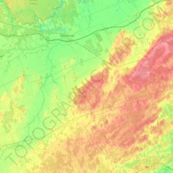
Name: North Stormont topographic map, elevation, terrain.
Average elevation: 82 m
Minimum elevation: 45 m
Maximum elevation: 124 m
Other topographic maps
Click on a map to view its topography, its elevation and its terrain.
Ingleside
Canada > Ontario > Stormont, Dundas and Glengarry Counties > South Stormont
Average elevation: 78 m
Hulbert
Canada > Ontario > Stormont, Dundas and Glengarry Counties > South Dundas
Average elevation: 73 m
Harmony
Canada > Ontario > Stormont, Dundas and Glengarry Counties > North Dundas
Average elevation: 78 m
Crysler
Canada > Ontario > Stormont, Dundas and Glengarry Counties > North Stormont
Average elevation: 69 m
South Lancaster
Canada > Ontario > Stormont, Dundas and Glengarry Counties > South Glengarry
Average elevation: 47 m
Chesterville
Canada > Ontario > Stormont, Dundas and Glengarry Counties > North Dundas
Average elevation: 74 m
Newington
Canada > Ontario > Stormont, Dundas and Glengarry Counties > South Stormont
Average elevation: 97 m
Long Sault
Canada > Ontario > Stormont, Dundas and Glengarry Counties > South Stormont
Average elevation: 77 m
Maxville
Canada > Ontario > Stormont, Dundas and Glengarry Counties > North Glengarry
Average elevation: 100 m
Dunvegan
Canada > Ontario > Stormont, Dundas and Glengarry Counties > North Glengarry
Average elevation: 87 m
Winchester
Canada > Ontario > Stormont, Dundas and Glengarry Counties > North Dundas
Average elevation: 76 m
Dalkeith
Canada > Ontario > Stormont, Dundas and Glengarry Counties > North Glengarry
Average elevation: 70 m
Glen Stewart
Canada > Ontario > Stormont, Dundas and Glengarry Counties > South Dundas
Average elevation: 76 m
Ormond
Canada > Ontario > Stormont, Dundas and Glengarry Counties > North Dundas
Average elevation: 77 m
Green Valley
Canada > Ontario > Stormont, Dundas and Glengarry Counties > South Glengarry
Average elevation: 79 m
Brown House Corner
Canada > Ontario > Stormont, Dundas and Glengarry Counties > South Glengarry
Average elevation: 67 m
Martintown
Canada > Ontario > Stormont, Dundas and Glengarry Counties > South Glengarry
Average elevation: 66 m
Moose Creek
Canada > Ontario > Stormont, Dundas and Glengarry Counties > North Stormont
Average elevation: 87 m
Summerstown
Canada > Ontario > Stormont, Dundas and Glengarry Counties > South Glengarry
Average elevation: 49 m
Stormont, Dundas and Glengarry
Canada > Ontario > Stormont, Dundas and Glengarry Counties
Average elevation: 153 m
Bainsville
Canada > Ontario > Stormont, Dundas and Glengarry Counties > South Glengarry
Average elevation: 50 m
Apple Hill
Canada > Ontario > Stormont, Dundas and Glengarry Counties > North Glengarry
Average elevation: 90 m
Fraser Point
Canada > Ontario > Stormont, Dundas and Glengarry Counties > South Glengarry
Average elevation: 46 m
Morrisburg
Canada > Ontario > Stormont, Dundas and Glengarry Counties > South Dundas
Average elevation: 79 m
Monkland
Canada > Ontario > Stormont, Dundas and Glengarry Counties > North Stormont
Average elevation: 102 m
Baltics Corners
Canada > Ontario > Stormont, Dundas and Glengarry Counties > North Glengarry
Average elevation: 95 m
Finch
Canada > Ontario > Stormont, Dundas and Glengarry Counties > North Stormont
Average elevation: 83 m
Glen Robertson
Canada > Ontario > Stormont, Dundas and Glengarry Counties > North Glengarry
Average elevation: 78 m
Glen Sandfield
Canada > Ontario > Stormont, Dundas and Glengarry Counties > North Glengarry
Average elevation: 74 m
Hallville
Canada > Ontario > Stormont, Dundas and Glengarry Counties > North Dundas
Average elevation: 91 m
Timmins Drain
Canada > Ontario > Stormont, Dundas and Glengarry Counties > North Dundas
Average elevation: 72 m
Baltics Corners
Canada > Ontario > Stormont, Dundas and Glengarry Counties > North Glengarry
Average elevation: 95 m
Glen Nevis
Canada > Ontario > Stormont, Dundas and Glengarry Counties > South Glengarry
Average elevation: 70 m
Williamsburg
Canada > Ontario > Stormont, Dundas and Glengarry Counties > South Dundas
Average elevation: 84 m
Williamsburg
Canada > Ontario > Stormont, Dundas and Glengarry Counties > South Dundas
Average elevation: 84 m
Dundela
Canada > Ontario > Stormont, Dundas and Glengarry Counties > South Dundas
Average elevation: 83 m