Geolocate

Nădlac topographic map

Click on the map to display elevation.

About this map

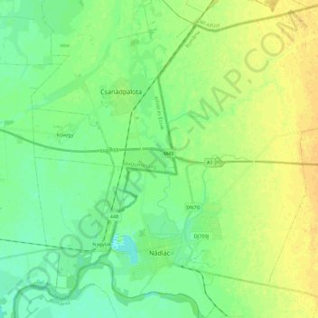
Name: Nădlac topographic map, elevation, terrain.

Location: Nădlac, Arad, 315500, Romania (46.13535 20.70531 46.28776 20.89054)

Average elevation: 93 m

Minimum elevation: 83 m

Maximum elevation: 105 m

Other topographic maps

Click on a map to view its topography, its elevation and its terrain.

Târnova

Romania > Arad

Average elevation: 129 m

Toc

Romania > Arad

Average elevation: 235 m

Munar

Romania > Arad

Average elevation: 101 m

Mihaiasa

Romania > Arad > Săvârșin

Average elevation: 527 m

Obârșia

Romania > Arad

Average elevation: 437 m

Lupești

Romania > Arad

Average elevation: 278 m

Munar

Romania > Arad > Munar

Average elevation: 101 m

Săvârșin

Romania > Arad

Average elevation: 217 m

Gear up for your next adventure:

👟Sport Hiking Sandals - Breathable footwear for water crossings and camp rest
🧴Outdoor Sunscreen - High SPF protection for high-altitude UV exposure
🚲Handlebar Phone Mount - View topographic-map.com live while cycling
🛏️Sleeping Bag - Warm and compact sleeping bags for outdoor camping
🩹Compact First Aid Kit - Pre-packed essentials for common trail injuries

As an Amazon Associate, this site earns from qualifying purchases at no extra cost to you.