Geolocate

Târnova topographic map

Click on the map to display elevation.

About this map

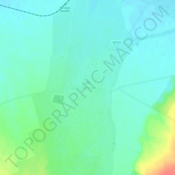
Name: Târnova topographic map, elevation, terrain.

Location: Târnova, Arad, 317360, Romania (46.29922 21.77595 46.33922 21.81595)

Average elevation: 129 m

Minimum elevation: 116 m

Maximum elevation: 170 m

Other topographic maps

Click on a map to view its topography, its elevation and its terrain.

Gurahonț

Romania > Arad

Average elevation: 383 m

Arad

Romania > Arad

Average elevation: 120 m

Nădlac

Romania > Arad

Average elevation: 93 m

Vinga

Romania > Arad

Average elevation: 129 m

Frumușeni

Romania > Arad

Average elevation: 147 m

Sântana

Romania > Arad

Average elevation: 109 m

Zărand

Romania > Arad

Average elevation: 104 m

Arad

Romania > Arad

Average elevation: 120 m

Bârzava

Romania > Arad

Average elevation: 292 m

Nădlac

Romania > Arad

Average elevation: 93 m

Cărand

Romania > Arad

Average elevation: 178 m

Vârfurile

Romania > Arad

Average elevation: 464 m

Arad

Romania > Arad

Average elevation: 120 m

Almaș

Romania > Arad

Average elevation: 334 m

Santana

Romania > Arad

Average elevation: 109 m

Beliu

Romania > Arad

Average elevation: 160 m

Arad

Romania > Arad

Average elevation: 120 m

Munar

Romania > Arad > Munar

Average elevation: 101 m

Săvârșin

Romania > Arad

Average elevation: 217 m

Gear up for your next adventure:

🥾Hiking Boots - Sturdy boots providing ankle support and traction on rugged trails
🥾Mountain Trail Shoes - High-traction shoes for mountain trails
🧶550 Survival Paracord - Versatile utility cord for emergency repairs and rigging
🚲Handlebar Phone Mount - View topographic-map.com live while cycling
🧥Waterproof Pants - Keep dry during rainy hiking conditions

As an Amazon Associate, this site earns from qualifying purchases at no extra cost to you.