Geolocate

Emery topographic map

Click on the map to display elevation.

About this map

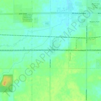
Name: Emery topographic map, elevation, terrain.

Location: Emery, Cerro Gordo County, Iowa, United States (43.11357 -93.30020 43.15357 -93.26020)

Average elevation: 361 m

Minimum elevation: 351 m

Maximum elevation: 379 m

Other topographic maps

Click on a map to view its topography, its elevation and its terrain.

Clear Lake

United States > Iowa > Cerro Gordo County

Average elevation: 373 m

Mason City

United States > Iowa > Cerro Gordo County

Average elevation: 352 m

Rockwell

United States > Iowa > Cerro Gordo County

Average elevation: 343 m

Clear Lake

United States > Iowa > Cerro Gordo County

Average elevation: 373 m

Rockwell

United States > Iowa > Cerro Gordo County

Average elevation: 343 m

Clear Lake

United States > Iowa > Cerro Gordo County

Average elevation: 373 m

Rockwell

United States > Iowa > Cerro Gordo County

Average elevation: 343 m

Rock Falls

United States > Iowa > Cerro Gordo County

Average elevation: 342 m

Gear up for your next adventure:

🧴Sunscreen SPF - Broad-spectrum sunscreen for outdoor activities
💧Hydration Pack - Hands-free hydration system for long hikes
🔦LED Headlamp - Hands-free lighting for early morning starts or late finishes
💡Solar Camping Lamp - Eco-friendly lighting for campsites
🕶️Polarized Sunglasses - Protect your eyes with durable polarized lenses

As an Amazon Associate, this site earns from qualifying purchases at no extra cost to you.