Geolocate

Bryson topographic map

Interactive map

Click on the map to display elevation.

Bryson topographic map, elevation, terrain

Bryson topographic map, elevation, terrain

About this map

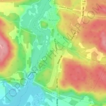
Name: Bryson topographic map, elevation, terrain.

Location: Bryson, Pontiac, Outaouais, Quebec, J0X 1H0, Canada (45.65329 -76.63023 45.68277 -76.60094)

Average elevation: 140 m

Minimum elevation: 84 m

Maximum elevation: 198 m

Routes: Pontiac GPS tracks, routes, trails, hikes

Other topographic maps

Click on a map to view its topography, its elevation and its terrain.

Zec Saint-Patrice

Canada > Quebec > Pontiac

Average elevation: 297 m

Lac d'Ours

Canada > Quebec > Pontiac > Litchfield

Average elevation: 239 m

Lac Pomponne

Canada > Quebec > Pontiac > Lac-Nilgaut

Average elevation: 347 m

Lac Gerta

Canada > Quebec > Pontiac > Otter Lake

Average elevation: 268 m

Greer Mount

Canada > Quebec > Pontiac > Thorne

Average elevation: 261 m

Lac Rueckwald

Canada > Quebec > Pontiac > Thorne

Average elevation: 223 m

L'Isle-aux-Allumettes

Canada > Quebec > Pontiac

Average elevation: 148 m

Bristol Mines

Canada > Quebec > Pontiac > Bristol

Average elevation: 93 m

Sand Bay

Canada > Quebec > Pontiac > Clarendon

Average elevation: 85 m

Lac Sopwith

Canada > Quebec > Pontiac > Otter Lake

Average elevation: 275 m

Otter Lake

Canada > Quebec > Pontiac

Average elevation: 262 m

Lac Antiquois

Canada > Quebec > Pontiac > Lac-Nilgaut

Average elevation: 366 m

Shawville

Canada > Quebec > Pontiac

Average elevation: 170 m

Danford Lake

Canada > Quebec > Pontiac > Alleyn-et-Cawood

Average elevation: 210 m

Bristol

Canada > Quebec > Pontiac

Average elevation: 140 m

Mansfield-et-Pontefract

Canada > Quebec > Pontiac

Average elevation: 238 m

Sheenboro

Canada > Quebec > Pontiac

Average elevation: 255 m

Clarendon

Canada > Quebec > Pontiac

Average elevation: 152 m

Thorne

Canada > Quebec > Pontiac

Average elevation: 222 m

Waltham

Canada > Quebec > Pontiac

Its territory, with a maximum elevation of just over 350 metres (1,150 ft), is sparsely populated, the majority of the population living along or near the Ottawa River. The northern portion is a vast extended tract of undeveloped land, dotted with lakes, such as Findlay, Landon, Gagnon, and Caughlin, which are…

Average elevation: 245 m