
Andersonville topographic map
Click on the map to display elevation.
About this map
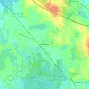
Name: Andersonville topographic map, elevation, terrain.
Average elevation: 314 m
Minimum elevation: 296 m
Maximum elevation: 344 m
Other topographic maps
Click on a map to view its topography, its elevation and its terrain.
Veterans Park
United States > Michigan > Oakland County > Highland Charter Township
Average elevation: 310 m
Waterbury Lake
United States > Michigan > Oakland County > Highland Charter Township
Average elevation: 308 m
Loon Lake
United States > Michigan > Oakland County > Waterford Township > Clintonville
Average elevation: 294 m
Highland State Recreation Area
United States > Michigan > Oakland County > Highland
West of Duck Lake Road in Highland State Recreation Area, a group of small moraines are locally called "mountains"—the highest elevation in the park, Mount Kanzer, is 1,150 feet (350 m) above sea level. The highland for which this recreation area is named is this group of moraines.
Average elevation: 302 m
Round Lake
United States > Michigan > Oakland County > Orion Charter Township
Average elevation: 303 m
Carpenter Lake Nature Preserve
United States > Michigan > Oakland County > Southfield
Average elevation: 207 m
Kent Lake
United States > Michigan > Oakland County > Milford Charter Township
Average elevation: 290 m