
Make a donation
Gear up for your next adventure:
As an Amazon Associate, this site earns from qualifying purchases at no extra cost to you.
Bingham Farms topographic map
Click on the map to display elevation.
Make a donation
Gear up for your next adventure:
As an Amazon Associate, this site earns from qualifying purchases at no extra cost to you.
About this map
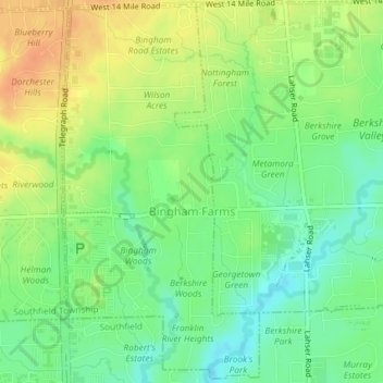
Name: Bingham Farms topographic map, elevation, terrain.
Average elevation: 222 m
Minimum elevation: 204 m
Maximum elevation: 242 m
Make a donation
Gear up for your next adventure:
As an Amazon Associate, this site earns from qualifying purchases at no extra cost to you.
Other topographic maps
Click on a map to view its topography, its elevation and its terrain.
Veterans Park
United States > Michigan > Oakland County > Highland Charter Township
Average elevation: 310 m
Waterbury Lake
United States > Michigan > Oakland County > Highland Charter Township
Average elevation: 308 m
Davisburg
United States > Michigan > Oakland County > Springfield Charter Township
Average elevation: 309 m
Make a donation
Gear up for your next adventure:
As an Amazon Associate, this site earns from qualifying purchases at no extra cost to you.
Round Lake
United States > Michigan > Oakland County > Orion Charter Township
Average elevation: 303 m
Hickory Ridge
United States > Michigan > Oakland County > Highland Charter Township
Average elevation: 326 m
Make a donation
Gear up for your next adventure:
As an Amazon Associate, this site earns from qualifying purchases at no extra cost to you.
Seven Harbors
United States > Michigan > Oakland County > Highland Charter Township
Average elevation: 314 m
Carpenter Lake Nature Preserve
United States > Michigan > Oakland County > Southfield
Average elevation: 207 m
Wood Creek Farms
United States > Michigan > Oakland County > Farmington Hills > Wood Creek Farms
Average elevation: 245 m
Make a donation
Gear up for your next adventure:
As an Amazon Associate, this site earns from qualifying purchases at no extra cost to you.