Geolocate

Southside topographic map

Click on the map to display elevation.

About this map

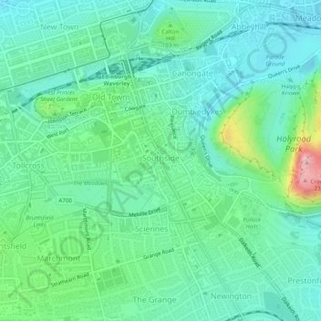
Name: Southside topographic map, elevation, terrain.

Location: Southside, City of Edinburgh, Scotland, United Kingdom (55.93693 -3.19157 55.95145 -3.16769)

Average elevation: 77 m

Minimum elevation: 26 m

Maximum elevation: 240 m

Other topographic maps

Click on a map to view its topography, its elevation and its terrain.

Ratho

United Kingdom > Scotland > City of Edinburgh

Average elevation: 80 m

Hillend

United Kingdom > Scotland > City of Edinburgh > Ratho

Average elevation: 67 m

Gogar

United Kingdom > Scotland > City of Edinburgh

Average elevation: 51 m

Newbridge

United Kingdom > Scotland > City of Edinburgh

Average elevation: 54 m

Crow Hill

United Kingdom > Scotland > City of Edinburgh

Average elevation: 68 m

Hays Park

United Kingdom > Scotland > City of Edinburgh

Average elevation: 45 m

Hillend

United Kingdom > Scotland > City of Edinburgh > Ratho

Average elevation: 67 m

Gogarbank

United Kingdom > Scotland > City of Edinburgh

Average elevation: 69 m

Gear up for your next adventure:

🧰Emergency Multi-Tool - Compact multi-tool for outdoor survival
🦟Insect Repellent - Keep mosquitoes and black flies away in wooded areas
🥾Waterproof Hiking Boots - Essential footwear for rugged terrain and wet Canadian trails
🚲Bike Repair Kit - Essential tools for on-trail mechanical issues
💧Hydration Pack - Hands-free hydration system for long hikes

As an Amazon Associate, this site earns from qualifying purchases at no extra cost to you.