Geolocate

Zug topographic map

Click on the map to display elevation.

About this map

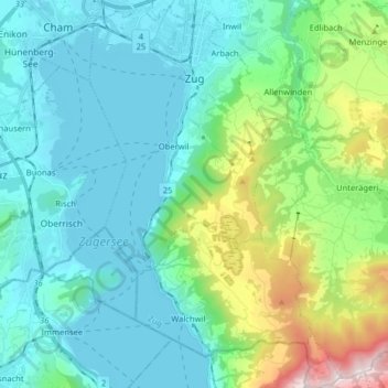
Name: Zug topographic map, elevation, terrain.

Location: Zug, Switzerland (47.08103 8.47383 47.18985 8.57759)

Average elevation: 640 m

Minimum elevation: 407 m

Maximum elevation: 1,563 m

Other topographic maps

Click on a map to view its topography, its elevation and its terrain.

Gottschalkenberg

Switzerland > Zug > Menzingen

Average elevation: 1,005 m

Zugerberg

Switzerland > Zug > Zug > Schönfels

Average elevation: 808 m

Allenwinden

Switzerland > Zug > Baar

Average elevation: 730 m

Morgarten

Switzerland > Zug > Oberägeri

Average elevation: 892 m

Wildspitz

Switzerland > Zug > Unterägeri

Average elevation: 1,266 m

Edlibach

Switzerland > Zug

Average elevation: 693 m

Gear up for your next adventure:

💧Reusable Water Bottle - Durable water bottles for hydration on trails
🧢Beanie Hat - Keep your head warm in cold weather
🔭Compact Binoculars - Lightweight optics for scouting trails and wildlife
🧥Waterproof Pants - Keep dry during rainy hiking conditions
🛁Quick-Dry Microfiber Towel - Space-saving towel that dries rapidly on the move

As an Amazon Associate, this site earns from qualifying purchases at no extra cost to you.