Geolocate

Maldon topographic map

Click on the map to display elevation.

About this map

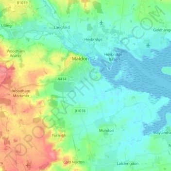
Name: Maldon topographic map, elevation, terrain.

Location: Maldon, Essex, England, United Kingdom (51.68507 0.64472 51.74605 0.80359)

Average elevation: 19 m

Minimum elevation: -1 m

Maximum elevation: 72 m

Gear up for your next adventure:

🧥Softshell Jacket - Windproof and breathable jacket for hiking
🔦LED Headtorch - Bright and durable light for night activities
👟Leg Gaiters - Keep debris, mud, and snow out of your boots
🥾Trekking Boots - Durable boots for long-distance trekking
📷Outdoor Action Camera - Capture high-elevation views and rugged adventures

As an Amazon Associate, this site earns from qualifying purchases at no extra cost to you.