Geolocate

Dante topographic map

Click on the map to display elevation.

About this map

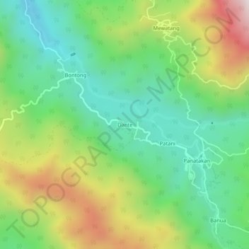
Name: Dante topographic map, elevation, terrain.

Location: Dante, Bungin, Enrekang, South Sulawesi, Sulawesi, Indonesia (-3.55990 119.93056 -3.51990 119.97056)

Average elevation: 859 m

Minimum elevation: 520 m

Maximum elevation: 1,468 m

Other topographic maps

Click on a map to view its topography, its elevation and its terrain.

Baraka

Indonesia > South Sulawesi > Enrekang

Average elevation: 827 m

Malua

Indonesia > South Sulawesi > Enrekang

Average elevation: 709 m

Alla

Indonesia > South Sulawesi > Enrekang

Average elevation: 1,037 m

Bungin

Indonesia > South Sulawesi > Enrekang

Average elevation: 1,238 m

Cendana

Indonesia > South Sulawesi > Enrekang

Average elevation: 152 m

Maiwa

Indonesia > South Sulawesi > Enrekang

Average elevation: 214 m

Malua

Indonesia > South Sulawesi > Enrekang

Average elevation: 709 m

Buntu Batu

Indonesia > South Sulawesi > Enrekang

Average elevation: 1,459 m

Gear up for your next adventure:

🧥Softshell Jacket - Windproof and breathable jacket for hiking
🥫Freeze-Dried Meals - Lightweight, high-calorie nutrition for multi-day treks
🧭GPS Handheld Device - Reliable GPS navigation for outdoor adventures
🥾Waterproof Trail Shoes - Shoes designed to handle wet terrain
🦯Trekking Poles - Reduced impact on joints for steep topographic climbs

As an Amazon Associate, this site earns from qualifying purchases at no extra cost to you.