Geolocate

Bolang topographic map

Click on the map to display elevation.

About this map

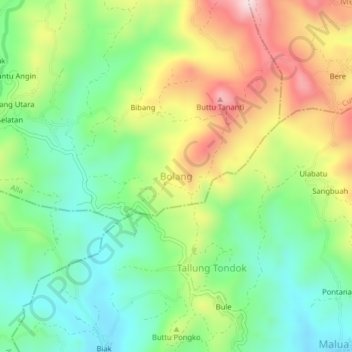
Name: Bolang topographic map, elevation, terrain.

Location: Bolang, Enrekang, South Sulawesi, Sulawesi, 91753, Indonesia (-3.38354 119.82579 -3.34354 119.86579)

Average elevation: 623 m

Minimum elevation: 463 m

Maximum elevation: 872 m

Other topographic maps

Click on a map to view its topography, its elevation and its terrain.

Baraka

Indonesia > South Sulawesi > Enrekang

Average elevation: 827 m

Malua

Indonesia > South Sulawesi > Enrekang

Average elevation: 709 m

Alla

Indonesia > South Sulawesi > Enrekang

Average elevation: 1,037 m

Bungin

Indonesia > South Sulawesi > Enrekang

Average elevation: 1,238 m

Cendana

Indonesia > South Sulawesi > Enrekang

Average elevation: 152 m

Maiwa

Indonesia > South Sulawesi > Enrekang

Average elevation: 214 m

Malua

Indonesia > South Sulawesi > Enrekang

Average elevation: 709 m

Buntu Batu

Indonesia > South Sulawesi > Enrekang

Average elevation: 1,459 m

Gear up for your next adventure:

💧Filtered Water Bottle - Safe drinking water on the go
🛏️Camping Sleeping Mat - Comfortable mats for sleeping outdoors
💧Collapsible Water Bottle - Space-saving water bottle for outdoor activities
🥾Light Hiking Boots - Lightweight and comfortable boots for day hikes
🦌Outdoor Trail Camera - Monitor wildlife activity near your favorite spots

As an Amazon Associate, this site earns from qualifying purchases at no extra cost to you.