Geolocate

Independence topographic map

Click on the map to display elevation.

About this map

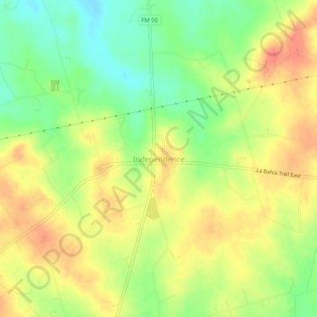
Name: Independence topographic map, elevation, terrain.

Location: Independence, Washington County, Texas, United States (30.29987 -96.36596 30.33987 -96.32596)

Average elevation: 106 m

Minimum elevation: 72 m

Maximum elevation: 136 m

Other topographic maps

Click on a map to view its topography, its elevation and its terrain.

Brenham

United States > Texas > Washington County

Average elevation: 98 m

Burton

United States > Texas > Washington County

Average elevation: 132 m

Burton

United States > Texas > Washington County

Average elevation: 132 m

Brenham

United States > Texas > Washington County > Brenham

Average elevation: 98 m

Gear up for your next adventure:

🛁Quick-Dry Microfiber Towel - Space-saving towel that dries rapidly on the move
🧢Hiking Sun Hat - Wide-brimmed protection for exposed mountain ridges
🔦LED Flashlight - Powerful and long-lasting flashlight for camping and emergencies
🚲Heavy Duty Bike Lock - Secure your bike at the trailhead or during stops
🧴Insect Repellent - Protect yourself from bugs during outdoor adventures

As an Amazon Associate, this site earns from qualifying purchases at no extra cost to you.