Geolocate

Burton topographic map

Click on the map to display elevation.

About this map

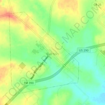
Name: Burton topographic map, elevation, terrain.

Location: Burton, Washington County, Texas, United States (30.17201 -96.60847 30.19298 -96.58775)

Average elevation: 132 m

Minimum elevation: 108 m

Maximum elevation: 159 m

Other topographic maps

Click on a map to view its topography, its elevation and its terrain.

Washington

United States > Texas > Washington County

Average elevation: 67 m

Chappell Hill

United States > Texas > Washington County

Average elevation: 83 m

Independence

United States > Texas > Washington County

Average elevation: 106 m

Chappell Hill

United States > Texas > Washington County

Average elevation: 83 m

Independence

United States > Texas > Washington County

Average elevation: 106 m

Chappell Hill

United States > Texas > Washington County

Average elevation: 83 m

Whitman

United States > Texas > Washington County

Average elevation: 79 m

Gear up for your next adventure:

🥾Waterproof Hiking Shoes - Durable shoes for wet and rugged trails
🧦Crew Hiking Socks - Comfortable socks for long-distance hikes
🪜Heavy Duty Carabiners - Multi-use clips for securing gear to your backpack
🧣Merino Neck Gaiter - Protects against wind, sun, and cold at high altitudes
🥾Trail Hiking Shoes - Durable shoes designed for rugged trails

As an Amazon Associate, this site earns from qualifying purchases at no extra cost to you.