
Tamworth Regional Council topographic map
Interactive map
Click on the map to display elevation.
About this map
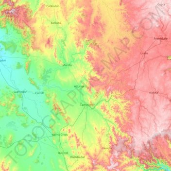
Name: Tamworth Regional Council topographic map, elevation, terrain.
Location: Tamworth Regional Council, New South Wales, Australia (-31.66185 150.14545 -30.18223 151.48458)
Average elevation: 692 m
Minimum elevation: 237 m
Maximum elevation: 1,455 m
Other topographic maps
Click on a map to view its topography, its elevation and its terrain.
Kunghur
Kunghur, Tweed Shire Council, New South Wales, 2484, Australia
Average elevation: 145 m
Cobramunga
Cobramunga, Murray River Council, New South Wales, 2732, Australia
Average elevation: 73 m
Newtown
Australia > New South Wales > Sydney
Newtown, Inner West, Sydney, Inner West Council, New South Wales, 2042, Australia
Average elevation: 22 m
Camden
Australia > New South Wales > Sydney
Camden, Sydney, Camden Council, New South Wales, 2570, Australia
Average elevation: 71 m
Mount Annan
Australia > New South Wales > Sydney
Mount Annan, Sydney, Campbelltown City Council, New South Wales, 2563, Australia
Average elevation: 115 m
Eastern Suburbs
Australia > New South Wales > Sydney
Eastern Suburbs, Sydney, Randwick City Council, New South Wales, Australia
Average elevation: 13 m
Northern Beaches
Australia > New South Wales > Sydney
Northern Beaches, Sydney, Northern Beaches Council, New South Wales, Australia
Average elevation: 67 m
Crystal Creek
Crystal Creek, Tweed Shire Council, New South Wales, 2484, Australia
Average elevation: 60 m
Tathra
Tathra, Bega Valley Shire Council, New South Wales, 2550, Australia
Average elevation: 23 m
Lower Boro
Lower Boro, Goulburn Mulwaree Council, New South Wales, 2580, Australia
Average elevation: 657 m
Hills District
Australia > New South Wales > Sydney
Hills District, Sydney, The Hills Shire Council, New South Wales, Australia
Average elevation: 91 m
Kosciuszko National Park
Kosciuszko National Park, New South Wales, Australia
Average elevation: 883 m
Tonderburine
Tonderburine, Gilgandra Shire Council, New South Wales, 2817, Australia
Average elevation: 326 m
Holmesville
Australia > New South Wales > Newcastle-Maitland
Holmesville, Newcastle-Maitland, Lake Macquarie City Council, New South Wales, 2286, Australia
Average elevation: 38 m
Hill End
Hill End, Bathurst Regional Council, New South Wales, 2850, Australia
Average elevation: 738 m
Brushy Creek
Brushy Creek, Armidale Regional Council, New South Wales, 2365, Australia
Average elevation: 1,155 m
Dunedoo
Dunedoo, Warrumbungle Shire Council, New South Wales, 2844, Australia
Average elevation: 467 m
Fairholme
Australia > New South Wales > Lachlan Shire Council
Fairholme, Lachlan Shire Council, New South Wales, 2871, Australia
Average elevation: 211 m
Wellington
Wellington, Dubbo Regional Council, New South Wales, 2820, Australia
Average elevation: 321 m
Queens Park
Australia > New South Wales > Sydney
Queens Park, Eastern Suburbs, Sydney, Waverley Council, New South Wales, 2022, Australia
Average elevation: 65 m
Poley Mountain
Poley Mountain, Gilgandra Shire Council, New South Wales, Australia
Average elevation: 465 m
Ben Lomond
Ben Lomond, Armidale Regional Council, New South Wales, 2365, Australia
Average elevation: 1,252 m
Newcastle-Maitland
Newcastle-Maitland, Port Stephens Council, New South Wales, Australia
Average elevation: 23 m
Rock Forest
Rock Forest, Bathurst Regional Council, New South Wales, 2795, Australia
Average elevation: 799 m
Kurrajong
Australia > New South Wales > Sydney
Kurrajong, Sydney, Hawkesbury City Council, New South Wales, 2758, Australia
Average elevation: 244 m
Rose Seidler House
Australia > New South Wales > Sydney
Rose Seidler House, Wahroonga, Upper North Shore, Sydney, Ku-ring-gai Council, New South Wales, 2076, Australia
Average elevation: 153 m
Shoalhaven City Council
Shoalhaven City Council, New South Wales, Australia
Average elevation: 272 m
Bogan Shire Council
Bogan Shire Council, New South Wales, 2825, Australia
Average elevation: 216 m
Lane Cove Municipal Council
Lane Cove Municipal Council, New South Wales, 2066, Australia
Average elevation: 41 m
Louth Park
Australia > New South Wales > Newcastle-Maitland
Louth Park, Newcastle-Maitland, Maitland City Council, New South Wales, 2320, Australia
Average elevation: 24 m
Toongabbie Creek
Australia > New South Wales > Sydney
Toongabbie Creek, Hills District, Sydney, City of Parramatta Council, New South Wales, Australia
Average elevation: 52 m
Sydney
Sydney, Council of the City of Sydney, New South Wales, Australia
Average elevation: 53 m
Maitland
Australia > New South Wales > Newcastle-Maitland
Maitland, Newcastle-Maitland, Maitland City Council, New South Wales, 2320, Australia
Average elevation: 11 m
Sydney International Regatta Centre
Australia > New South Wales > Sydney > Penrith > Upper Castlereagh
Sydney International Regatta Centre, Upper Castlereagh, Castlereagh, Penrith, Sydney, Penrith City Council, New South Wales, 2749, Australia
Average elevation: 19 m
Grafton
Grafton, Clarence Valley Council, New South Wales, Australia
Average elevation: 36 m
Roslyn
Roslyn, Upper Lachlan Shire Council, New South Wales, 2580, Australia
Average elevation: 918 m
Jugiong
Jugiong, Hilltops Council, New South Wales, 2726, Australia
Average elevation: 317 m
Fairy Creek
Australia > New South Wales > Wollongong City Council
Fairy Creek, North Wollongong, Wollongong City Council, New South Wales, 2500, Australia
Average elevation: 11 m
Larnook
Larnook, Lismore City Council, New South Wales, 2480, Australia
Average elevation: 193 m
Culburra Beach
Culburra Beach, Shoalhaven City Council, New South Wales, 2540, Australia
Average elevation: 5 m
Kandos
Kandos, Mid-Western Regional Council, New South Wales, 2848, Australia
Average elevation: 689 m
Kingscliff
Kingscliff, Tweed Shire Council, New South Wales, 2487, Australia
Average elevation: 5 m
Herron Park
Australia > New South Wales > Sydney
Herron Park, Mosman, Lower North Shore, Sydney, Mosman Municipal Council, New South Wales, 2088, Australia
Average elevation: 28 m
Upper North Shore
Upper North Shore, Ku-ring-gai Council, New South Wales, Australia
Average elevation: 119 m
Burwood Council
Australia > New South Wales > Sydney
Burwood Council, Inner West, Sydney, New South Wales, Australia
Average elevation: 24 m
Merriwagga
Australia > New South Wales > Carrathool Shire Council
Merriwagga, Carrathool Shire Council, New South Wales, 2652, Australia
Average elevation: 117 m
Prospect
Australia > New South Wales > Sydney
Prospect, Sydney, Blacktown City Council, New South Wales, 2148, Australia
Average elevation: 61 m
Hornsby
Australia > New South Wales > Sydney
Hornsby, Sydney, The Council of the Shire of Hornsby, New South Wales, 2077, Australia
Average elevation: 160 m
Moonbah
Moonbah, Snowy Monaro Regional Council, New South Wales, 2627, Australia
Average elevation: 1,129 m
Wollongong
Australia > New South Wales > Wollongong City Council
Wollongong, Wollongong City Council, New South Wales, 2500, Australia
Average elevation: 16 m