Geolocate

Wellington topographic map

Click on the map to display elevation.

About this map
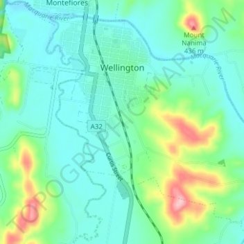
Name: Wellington topographic map, elevation, terrain.

Location: Wellington, Dubbo Regional Council, New South Wales, 2820, Australia (-32.59005 148.92930 -32.54215 148.99174)

Average elevation: 321 m

Minimum elevation: 282 m

Maximum elevation: 448 m

Other topographic maps

Click on a map to view its topography, its elevation and its terrain.
Rose Seidler House

Australia > New South Wales > Sydney

Average elevation: 153 m

Mount Annan

Australia > New South Wales > Sydney

Average elevation: 115 m

Grafton

Australia > New South Wales

Average elevation: 36 m

Herron Park

Australia > New South Wales > Sydney

Average elevation: 28 m

Dark Gully Reserve

Australia > New South Wales > Sydney

Average elevation: 14 m

Poley Mountain

Australia > New South Wales

Average elevation: 465 m

Castle Mountain

Australia > New South Wales > Quirindi

Average elevation: 578 m

Comara

Australia > New South Wales

Average elevation: 909 m

Gear up for your next adventure:

🥾Hiking Shorts - Breathable shorts suitable for summer hikes
🍽️Titanium Camping Spork - Ultralight and indestructible eating utensil
🧶550 Survival Paracord - Versatile utility cord for emergency repairs and rigging
🧭GPS Outdoor Watch - Smart watch for navigation and fitness tracking in nature
🥾Trekking Poles - Adjustable trekking poles to reduce knee stress and improve stability

As an Amazon Associate, this site earns from qualifying purchases at no extra cost to you.