Geolocate

Varnell topographic map

Click on the map to display elevation.

About this map

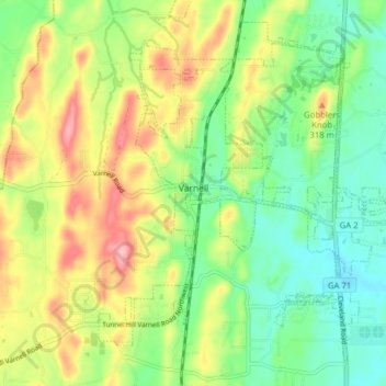
Name: Varnell topographic map, elevation, terrain.

Location: Varnell, Whitfield County, Georgia, 30756, United States (34.87136 -84.99511 34.92840 -84.91662)

Average elevation: 269 m

Minimum elevation: 216 m

Maximum elevation: 347 m

Other topographic maps

Click on a map to view its topography, its elevation and its terrain.

Dry Branch

United States > Georgia > Whitfield County

Average elevation: 294 m

Dalton

United States > Georgia > Whitfield County > Dalton > Dalton

Average elevation: 257 m

Gaston Park

United States > Georgia > Whitfield County > Dalton

Average elevation: 229 m

Rocky Face

United States > Georgia > Whitfield County

Average elevation: 278 m

Gear up for your next adventure:

🛶Waterproof Dry Bags - Keep electronics and clothes dry during river crossings
🧼Travel Hand Sanitizer - Keep hands clean when water is scarce
💡Solar Camping Lamp - Eco-friendly lighting for campsites
Tent Footprint - Protect tent floor and increase durability
🧊Portable Cooler - Keep food and drinks cold during outdoor adventures

As an Amazon Associate, this site earns from qualifying purchases at no extra cost to you.