Geolocate

Dalton topographic map

Click on the map to display elevation.

About this map

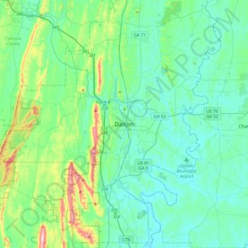
Name: Dalton topographic map, elevation, terrain.

Location: Dalton, Whitfield County, Georgia, 30720, United States (34.60919 -85.13025 34.92919 -84.81025)

Average elevation: 257 m

Minimum elevation: 190 m

Maximum elevation: 563 m

Gear up for your next adventure:

🥾Approach Shoes - Shoes designed for climbing approaches and rugged trails
🥾Hiking Leggings - Comfortable leggings for outdoor activities
🥾Light Hiking Boots - Lightweight and comfortable boots for day hikes
🚲MTB Frame Bag - Carry tools and maps directly on your bicycle frame
🧥Waterproof Pants - Keep dry during rainy hiking conditions

As an Amazon Associate, this site earns from qualifying purchases at no extra cost to you.