Geolocate

Láncara topographic map

Click on the map to display elevation.

About this map

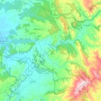
Name: Láncara topographic map, elevation, terrain.

Location: Láncara, Sarria, Lugo, Galicia, Spain (42.77587 -7.45330 42.92494 -7.21938)

Average elevation: 528 m

Minimum elevation: 353 m

Maximum elevation: 1,163 m

Other topographic maps

Click on a map to view its topography, its elevation and its terrain.

Lavandeira

Spain > Galicia > Sarria > Sarria

Average elevation: 636 m

Airexe

Spain > Galicia > Sarria > Sarria

Average elevation: 642 m

Rubial

Spain > Galicia > Sarria > Sarria

Average elevation: 487 m

Abadengo

Spain > Galicia > Sarria > O Incio

Average elevation: 655 m

Río

Spain > Galicia > Sarria

Average elevation: 803 m

Gear up for your next adventure:

Camping Tent - Weather-resistant tents suitable for 2 to 6 people
🧦Merino Wool Socks - Moisture-wicking comfort for long-distance hiking
🥾Waterproof Trail Shoes - Shoes designed to handle wet terrain
🍽️Titanium Camping Spork - Ultralight and indestructible eating utensil
Camping Groundsheet - Protect your tent from moisture and dirt

As an Amazon Associate, this site earns from qualifying purchases at no extra cost to you.