Geolocate

Powder Ridge topographic map

Click on the map to display elevation.

About this map

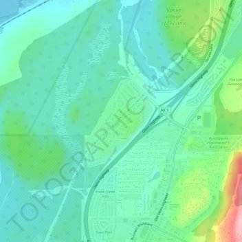
Name: Powder Ridge topographic map, elevation, terrain.

Location: Powder Ridge, Anchorage, Alaska, United States (61.33592 -149.58420 61.34649 -149.56817)

Average elevation: 89 m

Minimum elevation: 51 m

Maximum elevation: 215 m

Other topographic maps

Click on a map to view its topography, its elevation and its terrain.

Wilson Village

United States > Alaska > Anchorage > Anchorage

Average elevation: 48 m

Girdwood

United States > Alaska > Anchorage

Average elevation: 181 m

Anchorage

United States > Alaska > Anchorage

Average elevation: 124 m

Knik Arm

United States > Alaska > Anchorage

Average elevation: 72 m

South Yuyanq’ Ch’ex

United States > Alaska > Anchorage

Average elevation: 1,071 m

Gear up for your next adventure:

📷Outdoor Action Camera - Capture high-elevation views and rugged adventures
🦯Trekking Poles - Reduced impact on joints for steep topographic climbs
🦶Anti-Blister Balm - Prevents friction and hotspots during long ascents
🧦Crew Hiking Socks - Comfortable socks for long-distance hikes
🧰Emergency Multi-Tool - Compact multi-tool for outdoor survival

As an Amazon Associate, this site earns from qualifying purchases at no extra cost to you.