Geolocate

Indian topographic map

Click on the map to display elevation.

About this map

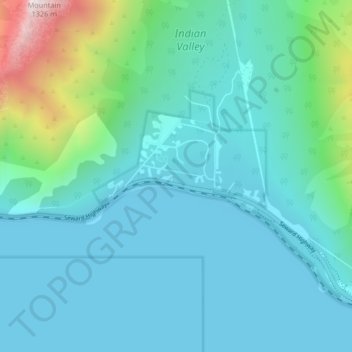
Name: Indian topographic map, elevation, terrain.

Location: Indian, Anchorage, Alaska, 99540, United States (60.96780 -149.53427 61.00780 -149.49427)

Average elevation: 199 m

Minimum elevation: 0 m

Maximum elevation: 1,292 m

Other topographic maps

Click on a map to view its topography, its elevation and its terrain.

Chugiak

United States > Alaska > Anchorage

Average elevation: 295 m

Laurel Acres

United States > Alaska > Anchorage

Average elevation: 25 m

Windemere

United States > Alaska > Anchorage

Average elevation: 33 m

Meadow View

United States > Alaska > Anchorage

Average elevation: 50 m

Hidden Cove

United States > Alaska > Anchorage

Average elevation: 19 m

Eagleridge

United States > Alaska > Anchorage

Average elevation: 134 m

Redoubt

United States > Alaska > Anchorage

Average elevation: 49 m

The Tablelands

United States > Alaska > Anchorage

Average elevation: 72 m

Windemere

United States > Alaska > Anchorage

Average elevation: 33 m

Gear up for your next adventure:

🚲Handlebar Phone Mount - View topographic-map.com live while cycling
🚲Bike Repair Kit - Essential tools for on-trail mechanical issues
🥾Light Trekking Boots - Supportive boots for multi-day treks
🔋Lithium AA Batteries - Long-lasting power that performs in extreme cold
🧥Insulated Jacket - Keep warm in cold outdoor conditions

As an Amazon Associate, this site earns from qualifying purchases at no extra cost to you.