
Madden topographic map
Click on the map to display elevation.
About this map
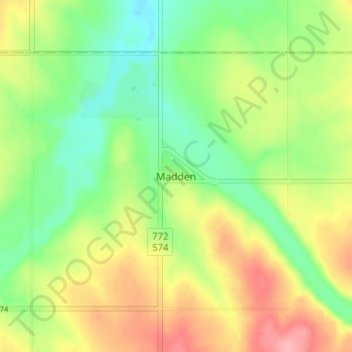
Name: Madden topographic map, elevation, terrain.
Location: Madden, Rocky View County, Alberta, Canada (51.41162 -114.30013 51.45162 -114.26013)
Average elevation: 1,151 m
Minimum elevation: 1,107 m
Maximum elevation: 1,208 m
Rocky View County trails, hiking, mountain biking, running and outdoor activities
Other topographic maps
Click on a map to view its topography, its elevation and its terrain.
Langdon
Canada > Alberta > Rocky View County
Langdon is located 12 km (7.5 mi) east of the City of Calgary at the intersection of Highway 560 (Glenmore Trail) and Highway 797, approximately 6 km (3.7 mi) south of the Trans Canada Highway and 7 km (4.3 mi) north of Highway 22X. It has an elevation of 1,005 m (3,297 ft).
Average elevation: 1,007 m