Geolocate

Story topographic map

Click on the map to display elevation.

About this map

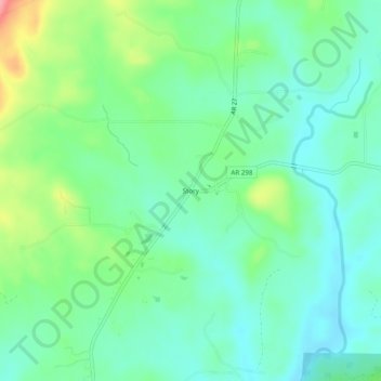
Name: Story topographic map, elevation, terrain.

Location: Story, Montgomery County, Arkansas, 71970, United States (34.67317 -93.53780 34.71317 -93.49780)

Average elevation: 220 m

Minimum elevation: 189 m

Maximum elevation: 298 m

Other topographic maps

Click on a map to view its topography, its elevation and its terrain.

Mount Ida

United States > Arkansas > Montgomery County

Average elevation: 215 m

Mount Ida

United States > Arkansas > Montgomery County

Average elevation: 215 m

Oden

United States > Arkansas > Montgomery County

Average elevation: 234 m

Oden

United States > Arkansas > Montgomery County

Average elevation: 234 m

Gear up for your next adventure:

🎒Fully Waterproof Backpack - Total protection for photography gear and electronics
Camping Groundsheet - Protect your tent from moisture and dirt
🧭GPS Handheld Device - Reliable GPS navigation for outdoor adventures
🎒Backpack Rain Cover - External shield to keep your entire pack dry
🧦Outdoor Socks - Durable socks designed for hiking and outdoor sports

As an Amazon Associate, this site earns from qualifying purchases at no extra cost to you.