Geolocate

Ramsey topographic map

Click on the map to display elevation.

About this map

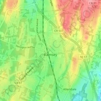
Name: Ramsey topographic map, elevation, terrain.

Location: Ramsey, Bergen County, New Jersey, 07446, United States (41.04051 -74.17628 41.07791 -74.11447)

Average elevation: 117 m

Minimum elevation: 73 m

Maximum elevation: 173 m

Other topographic maps

Click on a map to view its topography, its elevation and its terrain.

Ridgewood

United States > New Jersey > Bergen County

Average elevation: 56 m

Darlington

United States > New Jersey > Bergen County > Mahwah

Average elevation: 129 m

Drag Hill

United States > New Jersey > Bergen County > Mahwah

Average elevation: 252 m

Stag Hill

United States > New Jersey > Bergen County > Mahwah

Average elevation: 204 m

Green Hill

United States > New Jersey > Bergen County > Mahwah

Average elevation: 175 m

Fardale

United States > New Jersey > Bergen County > Mahwah

Average elevation: 124 m

Cragmere

United States > New Jersey > Bergen County > Mahwah

Average elevation: 136 m

Teterboro

United States > New Jersey > Bergen County > Teterboro

Average elevation: 12 m

Westwood

United States > New Jersey > Bergen County > Westwood > Westwood

Average elevation: 31 m

Gear up for your next adventure:

🧥Packable Rain Jacket - Breathable waterproof layer for unpredictable weather
💧Collapsible Water Bottle - Space-saving water bottle for outdoor activities
🥘Camping Cookware Set - Compact nesting pots and pans for trail cooking
🚑Survival Whistle - Signal for help across long distances in mountains
🧦Outdoor Socks - Durable socks designed for hiking and outdoor sports

As an Amazon Associate, this site earns from qualifying purchases at no extra cost to you.