Geolocate

Bolod topographic map

Click on the map to display elevation.

About this map

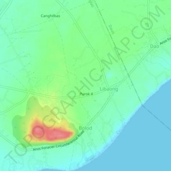
Name: Bolod topographic map, elevation, terrain.

Location: Bolod, Panglao, Bohol, Central Visayas, 6340, Philippines (9.55154 123.77225 9.59049 123.80540)

Average elevation: 22 m

Minimum elevation: 0 m

Maximum elevation: 81 m

Other topographic maps

Click on a map to view its topography, its elevation and its terrain.

Panglao

Philippines > Bohol > Panglao

Average elevation: 4 m

Daorong

Philippines > Bohol > Panglao > Danao

Average elevation: 3 m

Gear up for your next adventure:

💧Hydration Bladder - Hands-free hydration solution for long treks
🧭GPS Tracker - Track your location in remote areas safely
🧤Insulated Winter Gloves - Heavy-duty protection for sub-zero Canadian adventures
🛶Kayak Dry Bag - Waterproof storage for kayaking adventures
🪑Insulated Seat Pad - Protect your seat from cold rocks and wet logs

As an Amazon Associate, this site earns from qualifying purchases at no extra cost to you.