Geolocate

Moolboolaman topographic map

Click on the map to display elevation.

About this map

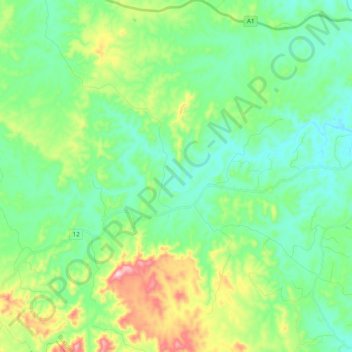
Name: Moolboolaman topographic map, elevation, terrain.

Location: Moolboolaman, Bundaberg Region, Queensland, 4671, Australia (-25.03847 151.72012 -24.94463 151.91401)

Average elevation: 142 m

Minimum elevation: 48 m

Maximum elevation: 401 m

Other topographic maps

Click on a map to view its topography, its elevation and its terrain.

Gin Gin

Australia > Queensland > Bundaberg Region > Gin Gin

Average elevation: 73 m

Isis River

Australia > Queensland > Bundaberg Region > Buxton

Average elevation: 12 m

Burrum River

Australia > Queensland > Bundaberg Region > Buxton

Average elevation: 20 m

Bundaberg

Australia > Queensland > Bundaberg Region

Average elevation: 18 m

Bundaberg

Australia > Queensland > Bundaberg Region

Average elevation: 18 m

Gear up for your next adventure:

🥤Collapsible Travel Cup - Saves space and weight in your mess kit
🧦Outdoor Socks - Durable socks designed for hiking and outdoor sports
🛶Waterproof Dry Bags - Keep electronics and clothes dry during river crossings
🚲Bike Repair Kit - Essential tools for on-trail mechanical issues
Camping Coffee Maker - Brew fresh coffee anywhere on the topographic map

As an Amazon Associate, this site earns from qualifying purchases at no extra cost to you.