
Forfar topographic map
Click on the map to display elevation.
About this map
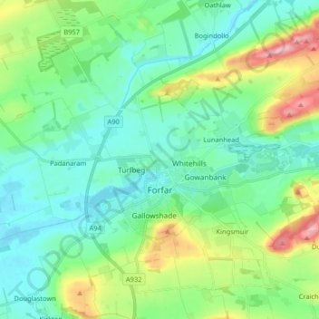
Name: Forfar topographic map, elevation, terrain.
Location: Forfar, Angus, Scotland, United Kingdom (56.60820 -2.96020 56.69719 -2.80990)
Average elevation: 95 m
Minimum elevation: 51 m
Maximum elevation: 227 m
Other topographic maps
Click on a map to view its topography, its elevation and its terrain.
Montrose
United Kingdom > Scotland > Angus
Montrose occupies a position on the North Bank of Montrose Basin at the mouth of the River South Esk on the East Coast of Scotland, 11 miles (18 km) NNE of Arbroath, 19 miles (31 km) SW of Stonehaven, and 7.2 miles (12 km) ESE of Brechin. The town lies 62.2 miles (100 km) NNE of Edinburgh, and 373.2 miles (601…
Average elevation: 22 m