Geolocate

Arbroath topographic map

Click on the map to display elevation.

About this map

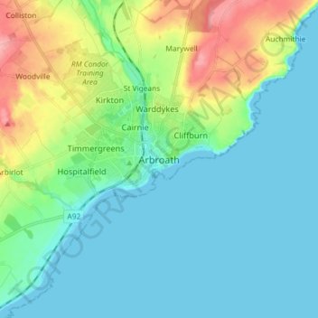
Name: Arbroath topographic map, elevation, terrain.

Location: Arbroath, Angus, Scotland, DD11 1DP, United Kingdom (56.51867 -2.62157 56.59867 -2.54157)

Average elevation: 24 m

Minimum elevation: 0 m

Maximum elevation: 98 m

Other topographic maps

Click on a map to view its topography, its elevation and its terrain.

Forfar

United Kingdom > Scotland > Angus

Average elevation: 95 m

Gear up for your next adventure:

🕶️Polarized Sunglasses - Protect your eyes with durable polarized lenses
🧰Emergency Multi-Tool - Compact multi-tool for outdoor survival
🥾Mountain Trail Shoes - High-traction shoes for mountain trails
🛏️Camping Sleeping Mat - Comfortable mats for sleeping outdoors
🎒Fully Waterproof Backpack - Total protection for photography gear and electronics

As an Amazon Associate, this site earns from qualifying purchases at no extra cost to you.