
Swindon topographic map
Click on the map to display elevation.
About this map
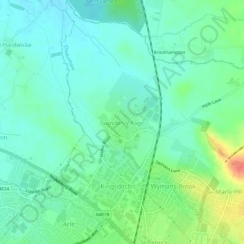
Name: Swindon topographic map, elevation, terrain.
Location: Swindon, Cheltenham, Gloucestershire, England, United Kingdom (51.91051 -2.11078 51.93887 -2.06723)
Average elevation: 41 m
Minimum elevation: 26 m
Maximum elevation: 76 m
Other topographic maps
Click on a map to view its topography, its elevation and its terrain.
Timbercombe
United Kingdom > England > Gloucestershire > Cheltenham > Charlton Kings
Average elevation: 159 m
Sudeley Castle
United Kingdom > England > Gloucestershire > Cheltenham > Sudeley
His elevation almost certainly came from his assistance in the suppression of the Wyatt rebellion.
Average elevation: 135 m