Geolocate

Sudeley Castle topographic map

Click on the map to display elevation.

Sudeley Castle

His elevation almost certainly came from his assistance in the suppression of the Wyatt rebellion.

Wikipedia (CC-BY-SA 3.0)

About this map

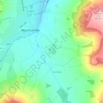
Name: Sudeley Castle topographic map, elevation, terrain.

Location: Sudeley Castle, Rushley Lane, Sudeley, Cheltenham, Gloucestershire, England, GL54 5JD, United Kingdom (51.94690 -1.95657 51.94783 -1.95564)

Average elevation: 135 m

Minimum elevation: 77 m

Maximum elevation: 269 m

Gear up for your next adventure:

🛏️Sleeping Bag - Warm and compact sleeping bags for outdoor camping
🥾Lightweight Hiking Boots - Boots for comfort and mobility on long hikes
🧴Waterproofing Spray - Restore the DWR coating on jackets and tents
🚲MTB Frame Bag - Carry tools and maps directly on your bicycle frame
💡Solar Camping Lamp - Eco-friendly lighting for campsites

As an Amazon Associate, this site earns from qualifying purchases at no extra cost to you.