Geolocate

Lyndhurst topographic map

Click on the map to display elevation.

About this map

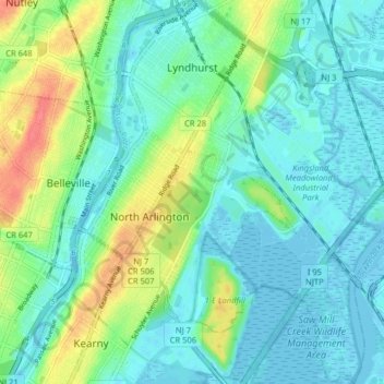
Name: Lyndhurst topographic map, elevation, terrain.

Location: Lyndhurst, Bergen County, New Jersey, 07071, United States (40.76203 -74.13999 40.82263 -74.08335)

Average elevation: 16 m

Minimum elevation: -3 m

Maximum elevation: 57 m

Other topographic maps

Click on a map to view its topography, its elevation and its terrain.

Ridgewood

United States > New Jersey > Bergen County

Average elevation: 56 m

Darlington

United States > New Jersey > Bergen County > Mahwah

Average elevation: 129 m

Drag Hill

United States > New Jersey > Bergen County > Mahwah

Average elevation: 252 m

Stag Hill

United States > New Jersey > Bergen County > Mahwah

Average elevation: 204 m

Green Hill

United States > New Jersey > Bergen County > Mahwah

Average elevation: 175 m

Fardale

United States > New Jersey > Bergen County > Mahwah

Average elevation: 124 m

Cragmere

United States > New Jersey > Bergen County > Mahwah

Average elevation: 136 m

Teterboro

United States > New Jersey > Bergen County > Teterboro

Average elevation: 12 m

Westwood

United States > New Jersey > Bergen County > Westwood > Westwood

Average elevation: 31 m

Gear up for your next adventure:

🥾Trail Running Boots - Durable shoes designed for trail running
💡LED Headlamp - Hands-free illumination for night hiking and camping
🦌Outdoor Trail Camera - Monitor wildlife activity near your favorite spots
🧥Waterproof Pants - Keep dry during rainy hiking conditions
🧢Sun Hat - Wide-brim hat for sun protection

As an Amazon Associate, this site earns from qualifying purchases at no extra cost to you.