Geolocate

Romance topographic map

Click on the map to display elevation.

About this map

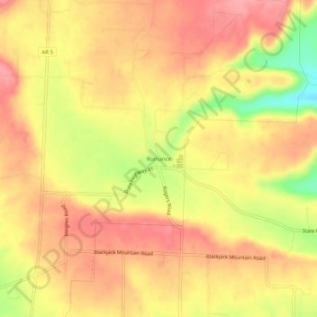
Name: Romance topographic map, elevation, terrain.

Location: Romance, White County, Arkansas, 72136, United States (35.22092 -92.07126 35.26092 -92.03126)

Average elevation: 192 m

Minimum elevation: 126 m

Maximum elevation: 227 m

Other topographic maps

Click on a map to view its topography, its elevation and its terrain.

Griffithville

United States > Arkansas > White County

Average elevation: 65 m

Searcy

United States > Arkansas > White County

Average elevation: 84 m

West Point

United States > Arkansas > White County

Average elevation: 66 m

Pangburn

United States > Arkansas > White County

Average elevation: 102 m

Bradford

United States > Arkansas > White County

Average elevation: 75 m

Judsonia

United States > Arkansas > White County

Average elevation: 74 m

Beebe

United States > Arkansas > White County

Beebe made international news in early January 2011 following the death of more than 3,000 red-winged blackbirds and European starlings over the community. Arkansas state wildlife authorities first received reports on December 31, 2010, shortly before midnight. Further investigation revealed the birds fell…

Average elevation: 71 m

Higginson

United States > Arkansas > White County

Average elevation: 68 m

Searcy

United States > Arkansas > White County

Average elevation: 84 m

Gear up for your next adventure:

🚲Handlebar Phone Mount - View topographic-map.com live while cycling
🥾Mountain Trail Shoes - High-traction shoes for mountain trails
Lightweight Camping Tent - Portable shelter optimized for Canadian backcountry camping
👟Trail Running Shoes - Agile footwear for fast-paced topographic exploration
🛏️Sleeping Bag - Warm and compact sleeping bags for outdoor camping

As an Amazon Associate, this site earns from qualifying purchases at no extra cost to you.