Geolocate

Rosas topographic map

Click on the map to display elevation.

About this map

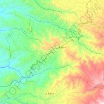
Name: Rosas topographic map, elevation, terrain.

Location: Rosas, Macizo, Cauca, Colombia (2.18703 -76.84249 2.31941 -76.64901)

Average elevation: 1,656 m

Minimum elevation: 852 m

Maximum elevation: 3,191 m

Other topographic maps

Click on a map to view its topography, its elevation and its terrain.

Toscana Circle

Colombia > Cauca > Popayán

Average elevation: 1,735 m

Torres

Colombia > Cauca > La Sierra

Average elevation: 1,759 m

Rio Negro

Colombia > Cauca > Puracé

Average elevation: 3,199 m

MONDOMO

Colombia > Cauca > Santander de Quilichao

Average elevation: 1,397 m

Peña Del Condado

Colombia > Cauca > Silvia > Peña Del Condado

Average elevation: 2,922 m

Páramo de Santo Domingo

Colombia > Cauca > Toribío

Average elevation: 3,886 m

El Condor

Colombia > Cauca > El Condor

Average elevation: 1,950 m

Inzá

Colombia > Cauca > Inzá > Inzá

Average elevation: 1,876 m

Gear up for your next adventure:

🎒Fully Waterproof Backpack - Total protection for photography gear and electronics
🥾Hiking Boots - Sturdy boots providing ankle support and traction on rugged trails
🧥Packable Rain Jacket - Breathable waterproof layer for unpredictable weather
🧭GPS Handheld Device - Reliable GPS navigation for outdoor adventures
Camping Groundsheet - Protect your tent from moisture and dirt

As an Amazon Associate, this site earns from qualifying purchases at no extra cost to you.