
Make a donation
Gear up for your next adventure:
As an Amazon Associate, this site earns from qualifying purchases at no extra cost to you.
Clay topographic map
Click on the map to display elevation.
Make a donation
Gear up for your next adventure:
As an Amazon Associate, this site earns from qualifying purchases at no extra cost to you.
Clay
The city of Charleston, the state capitol, is approximately 40 miles (64 km) from Clay to the southwest. Clay is centrally located within Clay County at 38°27′46″N 81°4′48″W / 38.46278°N 81.08000°W / 38.46278; -81.08000 (38.462855, -81.080024), along the Elk River and West Virginia Route 16 at an elevation of 708 feet (216 m). West Virginia Route 4 overlaps with Route 16 in the north of Clay. There is not much bottom land in Clay, as the river cuts a deep gorge through the city, limiting growth.
Make a donation
Gear up for your next adventure:
As an Amazon Associate, this site earns from qualifying purchases at no extra cost to you.
About this map
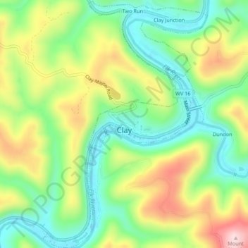
Name: Clay topographic map, elevation, terrain.
Location: Clay, Clay County, West Virginia, United States (38.44494 -81.09868 38.47734 -81.07116)
Average elevation: 312 m
Minimum elevation: 200 m
Maximum elevation: 484 m
Make a donation
Gear up for your next adventure:
As an Amazon Associate, this site earns from qualifying purchases at no extra cost to you.
Other topographic maps
Click on a map to view its topography, its elevation and its terrain.
Make a donation
Gear up for your next adventure:
As an Amazon Associate, this site earns from qualifying purchases at no extra cost to you.
Make a donation
Gear up for your next adventure:
As an Amazon Associate, this site earns from qualifying purchases at no extra cost to you.