
Make a donation
Gear up for your next adventure:
As an Amazon Associate, this site earns from qualifying purchases at no extra cost to you.
Indore topographic map
Click on the map to display elevation.
Make a donation
Gear up for your next adventure:
As an Amazon Associate, this site earns from qualifying purchases at no extra cost to you.
About this map
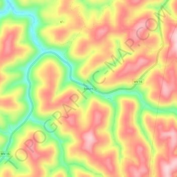
Name: Indore topographic map, elevation, terrain.
Location: Indore, Clay County, West Virginia, 25111, United States (38.33288 -81.16678 38.37288 -81.12678)
Average elevation: 384 m
Minimum elevation: 245 m
Maximum elevation: 484 m
Make a donation
Gear up for your next adventure:
As an Amazon Associate, this site earns from qualifying purchases at no extra cost to you.
Other topographic maps
Click on a map to view its topography, its elevation and its terrain.
Clay
United States > West Virginia > Clay County
The city of Charleston, the state capitol, is approximately 40 miles (64 km) from Clay to the southwest. Clay is centrally located within Clay County at 38°27′46″N 81°4′48″W / 38.46278°N 81.08000°W / 38.46278; -81.08000 (38.462855, -81.080024), along the Elk River and West Virginia Route…
Average elevation: 312 m