Geolocate

Rettendon Common topographic map

Click on the map to display elevation.

About this map

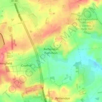
Name: Rettendon Common topographic map, elevation, terrain.

Location: Rettendon Common, Chelmsford, Essex, England, CM3 8EQ, United Kingdom (51.63519 0.53137 51.67519 0.57137)

Average elevation: 38 m

Minimum elevation: 6 m

Maximum elevation: 70 m

Other topographic maps

Click on a map to view its topography, its elevation and its terrain.

Broomfield

United Kingdom > England > Essex > Chelmsford

Average elevation: 47 m

Springfield

United Kingdom > England > Essex > Chelmsford

Average elevation: 42 m

Roxwell

United Kingdom > England > Essex > Chelmsford > Roxwell

Average elevation: 56 m

College Wood

United Kingdom > England > Essex > Chelmsford

Average elevation: 42 m

Rettendon

United Kingdom > England > Essex > Chelmsford > Rettendon

Average elevation: 26 m

Sandon

United Kingdom > England > Essex > Chelmsford > Sandon

Average elevation: 41 m

West Hanningfield

United Kingdom > England > Essex > Chelmsford

Average elevation: 56 m

Gear up for your next adventure:

🏃Hydration Running Vest - Carry water and maps close to your body for speed
💧Filtered Water Bottle - Safe drinking water on the go
🧤Insulated Winter Gloves - Heavy-duty protection for sub-zero Canadian adventures
🧦Thermal Socks - Warm socks for winter hiking or camping
🧥Packable Rain Jacket - Breathable waterproof layer for unpredictable weather

As an Amazon Associate, this site earns from qualifying purchases at no extra cost to you.