Geolocate

Stock topographic map

Click on the map to display elevation.

About this map

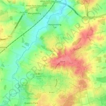
Name: Stock topographic map, elevation, terrain.

Location: Stock, Chelmsford, Essex, England, United Kingdom (51.64237 0.39685 51.69323 0.49245)

Average elevation: 63 m

Minimum elevation: 31 m

Maximum elevation: 101 m

Gear up for your next adventure:

🛁Quick-Dry Microfiber Towel - Space-saving towel that dries rapidly on the move
🧼Biodegradable Camp Soap - Environmentally friendly cleaning for gear and body
💧Reusable Water Bottle - Durable water bottles for hydration on trails
🎒Hiking Backpack - Lightweight and ergonomic backpacks for day hikes or multi-day treks
🥾Waterproof Hiking Boots - Essential footwear for rugged terrain and wet Canadian trails

As an Amazon Associate, this site earns from qualifying purchases at no extra cost to you.