Geolocate

Elstree topographic map

Click on the map to display elevation.

Elstree

In 1723, topographer John Norden noted in his book Speculum Britanniae, that in the county of Hartfordshire [sic] was one "Elstre or Eglestre". In an earlier edition, he writes.

Wikipedia (CC-BY-SA 3.0)

About this map

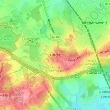
Name: Elstree topographic map, elevation, terrain.

Location: Elstree, Hertsmere, Hertfordshire, England, WD6 3BY, United Kingdom (51.62377 -0.31893 51.66377 -0.27893)

Average elevation: 105 m

Minimum elevation: 64 m

Maximum elevation: 152 m

Other topographic maps

Click on a map to view its topography, its elevation and its terrain.

Aldenham

United Kingdom > England > Hertfordshire > Hertsmere

Average elevation: 82 m

Shenley

United Kingdom > England > Hertfordshire > Hertsmere

Average elevation: 97 m

Aldenham

United Kingdom > England > Hertfordshire > Hertsmere

Average elevation: 82 m

Gear up for your next adventure:

🎒Hiking Backpack - Lightweight and ergonomic backpacks for day hikes or multi-day treks
🩹Moleskin Blister Pads - Direct protection for painful foot pressure points
🥾Approach Shoes - Shoes designed for climbing approaches and rugged trails
Camping Essentials - All-in-one gear for a comfortable camping trip
🧢Beanie Hat - Keep your head warm in cold weather

As an Amazon Associate, this site earns from qualifying purchases at no extra cost to you.