
Aldenham topographic map
Click on the map to display elevation.
About this map
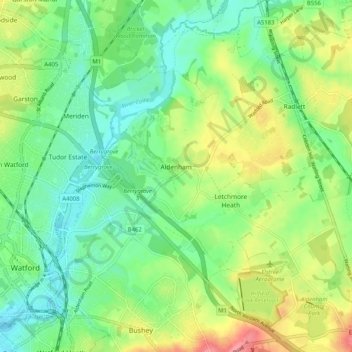
Name: Aldenham topographic map, elevation, terrain.
Average elevation: 82 m
Minimum elevation: 52 m
Maximum elevation: 136 m
Other topographic maps
Click on a map to view its topography, its elevation and its terrain.
Bushey
United Kingdom > England > Hertfordshire > Hertsmere
Bushey is a town in the Hertsmere borough of Hertfordshire in the East of England. It had a population of 25,328 in the 2011 census, rising to 28,416 in the 2021 census, an increase of 12.19%. This makes Bushey the second most populated town in Hertsmere. Bushey Heath is a large neighbourhood south east of…
Average elevation: 88 m
Bentley Heath
United Kingdom > England > Hertfordshire > Hertsmere > Potters Bar
Average elevation: 105 m
Elstree
United Kingdom > England > Hertfordshire > Hertsmere
In 1723, topographer John Norden noted in his book Speculum Britanniae, that in the county of Hartfordshire [sic] was one "Elstre or Eglestre". In an earlier edition, he writes.
Average elevation: 105 m
Well End
United Kingdom > England > Hertfordshire > Hertsmere > Borehamwood > Shenley
Average elevation: 108 m
Merry Hill
United Kingdom > England > Hertfordshire > Hertsmere > Bushey Heath > Merry Hill
Average elevation: 98 m
Bushey
United Kingdom > England > Hertfordshire > Hertsmere
Bushey is a town in the Hertsmere borough of Hertfordshire in the East of England. It had a population of 25,328 in the 2011 census, rising to 28,416 in the 2021 census, an increase of 12.19%. This makes Bushey the second most populated town in Hertsmere. Bushey Heath is a large neighbourhood south east of…
Average elevation: 88 m
Patchetts Green
United Kingdom > England > Hertfordshire > Hertsmere > Aldenham
Average elevation: 83 m
Elstree
United Kingdom > England > Hertfordshire > Hertsmere
In 1723, topographer John Norden noted in his book Speculum Britanniae, that in the county of Hartfordshire [sic] was one "Elstre or Eglestre". In an earlier edition, he writes.
Average elevation: 105 m