
Make a donation
Gear up for your next adventure:
As an Amazon Associate, this site earns from qualifying purchases at no extra cost to you.
Portstewart topographic map
Click on the map to display elevation.
Make a donation
Gear up for your next adventure:
As an Amazon Associate, this site earns from qualifying purchases at no extra cost to you.
About this map
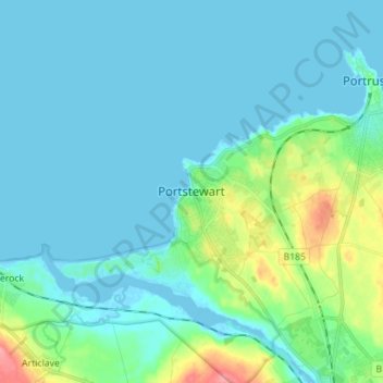
Name: Portstewart topographic map, elevation, terrain.
Average elevation: 13 m
Minimum elevation: -6 m
Maximum elevation: 80 m
Make a donation
Gear up for your next adventure:
As an Amazon Associate, this site earns from qualifying purchases at no extra cost to you.
Other topographic maps
Click on a map to view its topography, its elevation and its terrain.
Drumahoe
United Kingdom > Northern Ireland > County Londonderry > Derry/Londonderry
Average elevation: 46 m
Causeway Coast and Glens District
United Kingdom > Northern Ireland > County Londonderry
Average elevation: 101 m
Ballymagroarty
United Kingdom > Northern Ireland > County Londonderry > Derry/Londonderry
Average elevation: 73 m
Make a donation
Gear up for your next adventure:
As an Amazon Associate, this site earns from qualifying purchases at no extra cost to you.
Mid-Ulster District Council
United Kingdom > Northern Ireland > County Londonderry
Average elevation: 112 m
Foyle
United Kingdom > Northern Ireland > County Londonderry > Derry/Londonderry
Average elevation: 48 m
Make a donation
Gear up for your next adventure:
As an Amazon Associate, this site earns from qualifying purchases at no extra cost to you.
Lough Foyle
United Kingdom > Northern Ireland > County Londonderry > Londonderry/Derry
Average elevation: 61 m
Foyle
United Kingdom > Northern Ireland > County Londonderry > Derry/Londonderry
Average elevation: 48 m
Bay Road Park
United Kingdom > Northern Ireland > County Londonderry > Derry/Londonderry
Average elevation: 19 m
Make a donation
Gear up for your next adventure:
As an Amazon Associate, this site earns from qualifying purchases at no extra cost to you.