Geolocate

Castro Marim topographic map

Click on the map to display elevation.

About this map

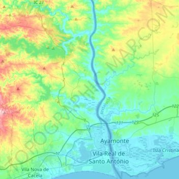
Name: Castro Marim topographic map, elevation, terrain.

Location: Castro Marim, Faro, Portugal (37.16685 -7.63707 37.39457 -7.41257)

Average elevation: 70 m

Minimum elevation: -2 m

Maximum elevation: 285 m

Other topographic maps

Click on a map to view its topography, its elevation and its terrain.

Aroal

Portugal > Faro > Boliqueime

Average elevation: 114 m

Faro

Portugal > Faro > Faro

Average elevation: 53 m

Folga

Portugal > Faro

Average elevation: 249 m

Paderne

Portugal > Faro > Paderne > Paderne

Average elevation: 87 m

Gear up for your next adventure:

🥾Mountaineering Boots - Supportive boots for climbing and high-altitude hiking
🥾Trail Hiking Socks - Comfortable socks to prevent blisters and fatigue
🥾Waterproof Hiking Boots - Boots keeping your feet dry in wet conditions
🦌Outdoor Trail Camera - Monitor wildlife activity near your favorite spots
💧Filtered Water Bottle - Safe drinking water on the go

As an Amazon Associate, this site earns from qualifying purchases at no extra cost to you.