
Folga topographic map
Click on the map to display elevation.
About this map
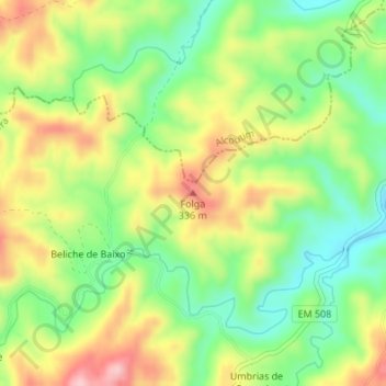
Name: Folga topographic map, elevation, terrain.
Location: Folga, Tavira, Faro, 8800-083, Portugal (37.27482 -7.64682 37.27492 -7.64672)
Average elevation: 249 m
Minimum elevation: 165 m
Maximum elevation: 354 m
Other topographic maps
Click on a map to view its topography, its elevation and its terrain.
Portimão
The geographical distribution of the altitude and relief of the municipality of Portimão generically follow the three types of territory present in the Barlavento: the coastal region, the Barrocal (a region between the coastal region and the mountains) and the mountains up north. Each one with their own…
Average elevation: 67 m