Geolocate

Linnich topographic map

Click on the map to display elevation.

About this map

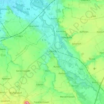
Name: Linnich topographic map, elevation, terrain.

Location: Linnich, Kreis Düren, North Rhine-Westphalia, 52441, Germany (50.93447 6.19356 51.02492 6.36219)

Average elevation: 84 m

Minimum elevation: 46 m

Maximum elevation: 194 m

Other topographic maps

Click on a map to view its topography, its elevation and its terrain.

Hambach

Germany > North Rhine-Westphalia > Kreis Düren

Average elevation: 111 m

Pier

Germany > North Rhine-Westphalia > Kreis Düren

Average elevation: 159 m

Duren

Germany > North Rhine-Westphalia > Kreis Düren > Duren > Duren

Average elevation: 135 m

Gear up for your next adventure:

🥾Approach Boots - Comfortable boots for hiking and climbing approaches
🥤Collapsible Travel Cup - Saves space and weight in your mess kit
🔦LED Headtorch - Bright and durable light for night activities
🧤Insulated Winter Gloves - Heavy-duty protection for sub-zero Canadian adventures
🧦Merino Wool Socks - Moisture-wicking comfort for long-distance hiking

As an Amazon Associate, this site earns from qualifying purchases at no extra cost to you.