
Samos topographic map
Click on the map to display elevation.
Samos
Samos is near the eastern mountains of Galicia (the mountains of Lóuzara, Serra do Oribio and Mountains of Albola). The mean altitude is over 700 m and the highest elevation is the mountain of O Oribio at 1,443 m. The Sarria River, a tributary of the Miño River, collects water from the western slopes of the mountains; the Lóuzara River drains the eastern slopes, flowing to the Lor River and then to the Sil River. There are three well-differentiated areas: the central one, where the population is mainly located; the north area, more open and with smooth slopes, and Lóuzara, the southern area, with mountains and valleys.
About this map
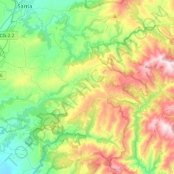
Name: Samos topographic map, elevation, terrain.
Location: Samos, Sarria, Lugo, Galicia, Spain (42.60339 -7.39270 42.78474 -7.17129)
Average elevation: 742 m
Minimum elevation: 350 m
Maximum elevation: 1,460 m
Other topographic maps
Click on a map to view its topography, its elevation and its terrain.