Geolocate

Woodgate topographic map

Click on the map to display elevation.

About this map

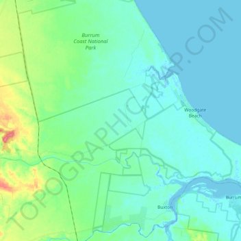
Name: Woodgate topographic map, elevation, terrain.

Location: Woodgate, Bundaberg Region, Queensland, 4660, Australia (-25.18144 152.39543 -25.05315 152.63302)

Average elevation: 13 m

Minimum elevation: -3 m

Maximum elevation: 70 m

Other topographic maps

Click on a map to view its topography, its elevation and its terrain.

Gin Gin

Australia > Queensland > Bundaberg Region > Gin Gin

Average elevation: 73 m

Isis River

Australia > Queensland > Bundaberg Region > Buxton

Average elevation: 12 m

Burrum River

Australia > Queensland > Bundaberg Region > Buxton

Average elevation: 20 m

Bundaberg

Australia > Queensland > Bundaberg Region

Average elevation: 18 m

Bundaberg

Australia > Queensland > Bundaberg Region

Average elevation: 18 m

Gear up for your next adventure:

🏃Hydration Running Vest - Carry water and maps close to your body for speed
🥾Waterproof Hiking Shoes - Durable shoes for wet and rugged trails
Lightweight Backpacking Tent - Compact tent for efficient hiking trips
🥽Outdoor Goggles - Protective eyewear for outdoor activities
🧦Thermal Socks - Warm socks for winter hiking or camping

As an Amazon Associate, this site earns from qualifying purchases at no extra cost to you.